
New Thesis: HERITAGE SANCTUARY FOR GEOLOGY _AIUB
New Thesis: HERITAGE SANCTUARY FOR GEOLOGY _AIUB
Project: HERITAGE SANCTUARY FOR GEOLOGY.
Student name: Shahira Sarwat
Studio: X (Thesis)
Studio Teacher: Ashik Vaskor Mannan, Irfat Alam
Project Supervisor: Arefeen Ibrahim
Year: Fall 2023
University: American International University Bangladesh (AIUB)
Site Area: 22.59 acre
Project Brief: HERITAGE SANCTUARY FOR GEOLOGY
The project focuses on preserving the unique geological features in Jaflong, Sylhet from the Eocene age (55.8 million years ago) i.e., the only open limestone, layers of ‘Kopili Shale’, and boulder beds along with hillocks. These hillocks have been declared as geological heritage due to the presence of shale layers exposed on the surface as well as beneath the ground, and need to be conserved against extinction for man-made or natural reasons.

The Site
Jaflong of Sylhet in Bangladesh has played a very important role for a long time to the Geological Researchers, Teachers, and Students for its diversified geological structure and heritage. The area is situated at the bank of Piyain river near Bangladesh – India border. Almost all the available siltstone layers inside Bangladesh are situated in this region in an open state. Such layers are not available anywhere else in Bangladesh. Five formations from the Tertiary period and three deposits from the Holocene period showcase the area’s rich geological heritage. Notably, the site showcases the exposed Shale formations dating back millions of years to the Eocene age.

Jaflong owes its formation to the intricate geological processes, particularly the phenomenon of subduction. Over millions of years, the tectonic plates underlying the region have been in constant motion, with one plate sliding beneath another. This subduction process has played a pivotal role in shaping the landscape, gradually uplifting the terrain and exposing layers of ancient geological formations, including the renowned Kopili Shale layer.

As the plates continue to interact, the forces generated have led to the gradual emergence of Jaflong, with its distinctive geological features becoming increasingly visible over time. Thus, the site stands as a testament to the dynamic forces of nature and a timeless heritage of geological evolution. The site sits at an elevation of 108 feet above sea level, and harbors 42 different species of plants, contributing to its ecological richness. While nearby stone quarries pose minimal direct impact, occasional illegal extraction activities threaten the site’s integrity.

Design Considerations and Form Development

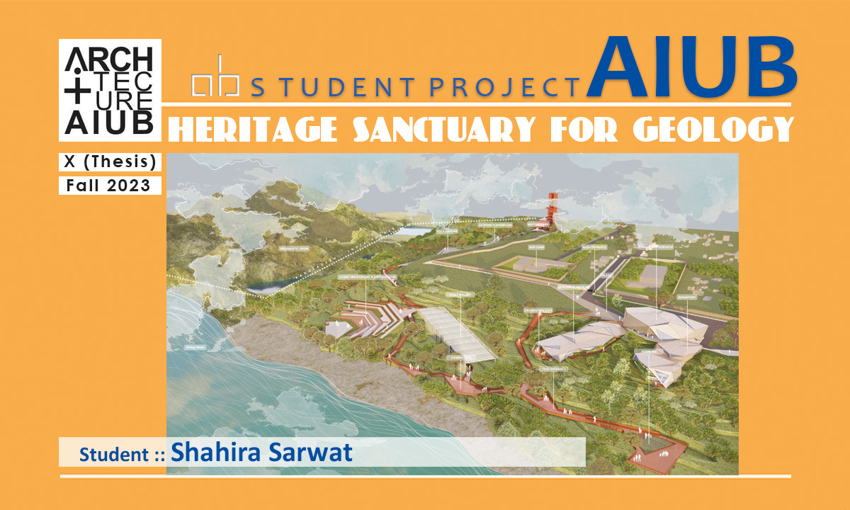
Emphasizing the site’s natural forces, the location of the geological heritage (Kopili shale) on the site has been considered first, along with the depth, and the buffer radius it is assumed to cover below ground for this HERITAGE SANCTUARY FOR GEOLOGY project. Intending for the heritage to remain the highlight, the design resembles the embedded stones’ shapes, reminiscent of Jaflong, Sylhet, with a concept of integrating the massing seamlessly with its surroundings. Since the entire 22 acres have been declared as heritage, a minimal footprint massing has been designed, along with other scenic considerations such as the view of Meghalaya in India to the North, and the Piyain river to the west.


Environmental factors, including the nearby Dawki fault line influence the design, along with the concept of stabilizing an environment against earthquake vulnerability. In light of extensive research indicating its resilience in earthquake-prone regions, a cut-and-cover structure has been deliberately selected for this site. Additionally, by incorporating shear walls, truss systems in the roof, and space frames into the building design, the structural integrity has been enhanced. Moreover, a geotechnical ground improvement method is proposed to mitigate landslide risks in the hilly terrain.

Program requirements and outcome

The project covers a range of programs considering awareness, conservation, and geo tourism in the area; such as a geological museum, geopark, seismic observation center, library, training institute, dormitory, and a conference center.


Geological Museum: The geological museum encompasses a diverse array of sectors, displaying a collection of geological rocks collected from all over Bangladesh and the neighboring countries, offering unique insights into the fascinating world of geology. The first sector, “A Walk-Through Time,” serves as a captivating journey through Earth’s evolution over millennia. Moving on to “Reading the Rocks,” the museum delves into the earliest formations of rocks offering a glimpse into the Earth’s ancient past.

In “The Dynamic Earth” sector, visitors explore the complex workings of earthquakes and tectonics, and the forces that shape our planet’s surface. Transitioning to “The Habitable Earth,” the museum illuminates the formation of seas and continents, unraveling the mysteries behind the Earth’s ever-changing landscape. Lastly, “Framing the Fossil” presents a unique exhibit of fossils that are meticulously arranged on the ground, replicating their natural placement in geological strata where visitors can see ancient remnants of prehistoric life.
Geopark: The geopark serves as a focal point for geotourism, attracting wide range of visitors to experience the geological wonders of Jaflong. This influx of tourists also contributes significantly to the economic vitality of the area, sustaining local businesses. Picking guidelines from “UNESCO Global Geoparks – A Global Framework” and scientific researchers, a walking trail has been designed with interactive and educational points throughout.


Other programs: The incorporation of a dormitory within the contour site presented unique challenges in terms of spatial organization. Despite, the dormitory blends with the concept into the site’s natural surroundings while accommodating the dormitory’s functional requirements for its guests. The geological library has been designed considering the extensive collection of geological resources, with dedicated spaces for mapping tables and oversized research materials, ensuring convenient access and utilization of these specialized resources. The Seismic Observation Centre encompasses a team of researchers and a suite of specialized laboratories, including the Geomorphology Lab, Sedimentation Lab, Instrumentation Lab, Clean Microscopy facility, GPS Control Room, Seismograph Machine Room, and Archives.


Conclusion: HERITAGE SANCTUARY FOR GEOLOGY
The preservation of these geological formations, mainly Kopili Shale from the Eocene time period, is essential not only for safeguarding the heritage but also for maintaining the delicate balance of biodiversity that depends on them. By recognizing the interconnectedness between geology and biodiversity, the project ensures the long-term sustainability of both natural resources for future generations to enjoy and for researchers to study, while safeguarding the natural heritage within a sanctuary setting and attempting to attain goals 8 and 9 of the 17 SDGs.

- #AIUB #American International University Bangladesh #HERITAGE SANCTUARY FOR GEOLOGY #X(Thesis) #Architecture_AIUB